Saturday, November 24, 2007

Thanksgiving in Carlsbad


We awoke Thursday morning to light snow coming down – it got heavier as morning progressed, but it was melting so that by early afternoon when the snow stopped, there was only a little still on the ground.

Thursday early evening found us toasting the day with some Sparkling Burgundy from Pleasant Valley Winery in the Finger Lakes region of New York state, where we had visited – in what seems like forever ago – on this trip. Then it was on to dinner with Jim, Sally and Sally's mother – a great time!

After dinner, Sally made arrangements for Clara and me to ride the great Carlsbad riverboat for "Christmas on the Pecos!" All the folks who live on the banks of the river decorate their back yards with all manner of light displays, ranging from videos showing on very large screens to the more traditional lights reading "Happy Holidays," and for some strange reason that I cannot get my head around, a large number of crosses . . . for Christmas . . . the birth of "the Christ-child" . . . crosses . . .

Thursday, November 22, 2007

Davis Mountains State Park


As we were pulling into our camping space, the fellow in the trailer on the other side of the road from us called across, "What part of Washington are you from?" Amazingly, for the fourth time on this journey, we had run across a fellow Seattle-ite! If I knew much of anything about mathematics, I could probably figure out the probability of such a repeated occurrence – let's see, out of 81 nights of camping, with 50 states to come from, to have four from, not only the same state, but the same metropolitan area – hmmm . . .

So happy hour was another pleasant evening – warm enough to sit outside, no mosquitoes, congenial company to visit and share a glass with – perhaps I'm prejudiced but there must be something special about Seattle-ites since we haven't met one yet that we didn't like . . . of course it's easy to say that when you're in Texas . . .

Partway from Davis Mountains to Carlsbad, it was time to stop for lunch in Pecos, TX – the first really good Mexican food we've had on this trip. I had never before heard of a "Chile con queso steak," but it was superb. And of course Clara had to have the Sopaipillas for dessert – in case you didn't know, "sopaipilla" means "little pillow" in Spanish, it's a light, puffy pastry served with honey, rather similar to the beignets found in New Orleans. The restaurant was Alfredo's and the mural out front was a pleasure.

From Terlingua to Presidio


In this first picture, I was simply impressed by the layers of color I could see in the hills on the Mexican side. In the second you can see the mighty Rio Grande with the U.S. on one side and Mexico on the other – and you could walk across if it were legal . . .

The scenery along the road was spectacular, even enhanced by the trio of tepees installed many years ago as a part of LadyBird's highway beautification program.

The caption for this last picture reads "Now we're going to put that fence right over . . . there . . . "

Big Bend National Park


We arrived in Big Bend and went straight to Rio Grande Village RV Park, thinking we would need the hook-ups and the showers, etc. Well, that was a mistake as the "Park" was more like a "Parking Lot," and the showers were "Pay-as-you-wash!" So the next day we set off for Chisos Basin Campground – set in the little inset basin that you can see to the right of the middle of this first picture, part way, but not all the way, up the mountains. [The inveterately curious can look at Notes #1 and #2 for the origin of the name "Chisos."]

On Sunday morning we hiked the half-mile trail up to the Chisos Mountain Lodge for their buffet breakfast, and, coincidentally, the gorgeous scenery on the way up. Here's a picture of the Lodge's dining building with picture window out on the scenery.

After breakfast, on the way down, we hiked over to where you could look out through "The Window," a formation that appears to open up to the valley floor below. Later we got a view of the campground from above.

While at the campground, we were "forced" to wake up each morning and look out at the
surrounding countryside, as you can see in pictures six and seven – it was really tough to stay there.

Monday, after another breakfast at their buffet (during which the kitchen actually ran out of sausage and bacon) we set off for our last chat with Marguerite and on down the road to Presidio, but that's in the next installment.

Note #1 "Several explanations of the origin of the name of the range have been offered over the years. One held that chisos means "ghost," and that the mountains were named for the ghost of the Apache chief Alsate, who hid in the mountains for a time. Another version was that chisos was the plural of chis, meaning "clash of arms" (chischás in Castilian), since some reported hearing battle sounds at night in the mountains as the ghosts of Spanish soldiers returned to fight again. A third story was that chisos was a corruption of the Spanish hechizos, "bewitchments" or "enchantments." The mountains were almost certainly named, however, for the Chizos Indians."

Note #2 "Beautiful they are but the Chisos are also mountains of mystery and remain a little aloof from the first time visitor. The mystery even extends to their name. I had been taught as a child that the name Chisos was Spanish for “ghost”. Not so I find. My Spanish dictionary doesn’t even have a “ch” section. But the experts are generally agreed that the mountains were named for the Chizos Indians and that “Chizos” meant ghost in their language. Since the Chizos did not have a written language and there are no more Chizos Indians around to speak their language I suppose we shall have to take that on faith---unscientific as that may be. There definitely is a ghostlike quality to the Chisos in the early morning fog."

Tuesday, November 20, 2007

Unintended consequences of our fear


On Saturday, our first full day at Big Bend National Park, all 800 thousand plus acres of it, we did the logical thing – left the park to visit a quilt shop in the town of Terlingua! There Clara met Marguerite, and heard the tale that is the topic of this "Special Edition." [Parenthetically, the jist of this tale has been confirmed in separate conversations with two different volunteer Rangers here at the Park.]

For many years (Big Bend was opened in 1944) one of the charms of BBNP was the opportunity to be rowed across the Rio Grande for lunch in a Mexican home in the river-side community of Boquillas, or perhaps the further up-stream community of Santa Elena. In addition to this informal "transit-and-lunch" feature – which incidentally was mentioned in our "Welcome to Big Bend National Park" film presentation at the Visitor Center day before yesterday – many Mexicans came across to work (and shop) in the villages of Terlingua and Study Butte, TX. This was regarded as a normal way of life – after all, the Rio Grande is comparatively small and slow along here – where villages (and villagers) on opposite sides of a river work and live together.

No more! Since 9/11 the Mexicans have been told they'll be arrested (and some have been) if they row across the river as they have done for the past, nearly 60, years. To come across they must travel either to Del Rio, TX (more than 200 miles east) or Presidio, TX (more than 200 miles west) where there are official border crossings.

However, these villages are essentially cut off within their own country – roads from the villages to either of these border crossings (or to anywhere else in Mexico for that matter) are either very primitive or completely non-existent.

The result – according to Marguerite, villagers in Terlingua, and Rangers in BBNP, have observed former employees and acquaintances across the river nearly destitute and hungry. Little local efforts to provide relief have been mounted, but they're small and regulations make them quite complicated, requiring more than two hundred miles of travel to deliver something to someone less than a hundred feet away!

Where Marguerite fits into this picture is, of course, quilts. Women in the village of Boquillas have been making quilts, and for the past two years, a woman named Katie Tetreault, from Alpine, TX, has put together a show and sale, in Alpine, "The Ladies of Boquillas, Mexico present their Annual Boquillas Quilt Show and Sale." Unfortunately, none of the "Ladies of Boquillas" can attend since they would have to travel either to Del Rio or to Presidio to get a Visa to come across . . .

How did the "Ladies of Boquillas" get their start? Someone donated a treadle machine and some patterns – which the "Ladies" cannot read, so they look at the pictures and pattern pieces and improvise, and the result is more "folk art" than professional stitchery. Someone else donated an electric machine which was of no use since there was no electricity – until someone else put together a system with solar panels and brought that down.

Another woman, Cynta de Narvaez, makes the journey to Boquillas, taking fabric and sales proceeds over and bringing quilts back. Cynta, the child of Cuban parents in New York City, came to this area many years ago to work as a guide for excursions across the river to areas of interest in Mexico. (But, no more, as such excursions are not possible under post 9/11 regulations.) Marguerite, for her part, sells their quilts at her shop, with 100% of the proceeds going to the "Ladies of Boquillas."

Marguerite asks, "Is this really necessary in order to "secure our borders"? Are we not being a bit too rigid in the effort? Could we not devise some local system that would allow the continuation of the traditions of the past while still protecting our borders?" [The cynic in me says that GWB governs ONLY because he has played the "fear card" to the hilt!]

Would you like to have a part in helping these "Ladies of Boquillas" who are trying to help themselves? Fabric of all types will be put to good use, cash is always welcome when you have none. You can contact Cynta de Narvaez at (432) 371-2226 (or at P.O. Box 166, Terlingua, TX) or Katie Tetreault at (432) 837-3587 or Marguerite Chanslor at (432) 371-2292 (or at P.O. Box 142, Terlingua, TX 79852.) Additionally, Cynta is co-founder of an organization called Fronteras Unlimited which has a web-site at www.fronterasunlimited.org with her e-mail at cynta@fronterasunlimited.org

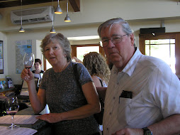
Here's a couple pictures of Marguerite with Clara and a picture of a child's quilt done by Silvia Gonzales, described as one of Boquillas better quilters.

Monday, November 19, 2007

Seminole Canyon


Seminole Canyon

When we pulled into Seminole Canyon State Park, Clara knew she was home. Evidently it's the "in utero" vibrations of being born in Hardin, Montana, in the "Big Sky" country, but she has always felt most at home in the widest of wide open spaces, preferably with Sonoran desert vegetation surrounding her – and that's Seminole Canyon.

The outstanding attraction of SCSP, other than its general environs, is the array of pictographs found there; so Clara took a guided hike down into the canyon to view some of them. The pictographs are found in a "gallery" underneath that rock outcropping in the picture, so it's down into the canyon then up to the "gallery." These particular pictographs are thought to be about 8,000 years old, and evidently the shelter provided by the rock outcropping is what has kept them sheltered from the weather and still visible today.

The sculpture is done in the style of the pictographs and is called "The Peace Bringer."

Along the way they passed what is thought to be the oldest mesquite tree in existence, about 200 years. (Would you want to live to be 200 if you knew you'd wind up looking like that??)

In case you're one of the inveterately curious who is wondering about the name "Seminole Canyon" since the Seminoles are from Florida, here's the straight skinny. From 1872 until 1914 there was a mixed troop of Seminoles and black Americans who were garrisoned at Fort Clark, TX, whose job was to guard the western frontiers of Texas against marauding Apaches and Comanches
from Arizona and New Mexico. The troop was recognized as having done an excellent job, and the canyon was named in their honor.

Across Louisiana and into Texas


When we stopped at the Texas Welcome Station, the mile marker read "880," and I thought "This is one of God's cruelest jokes – you must choose between eternal hell-fire and damnation or 880 miles across Texas!" We haven't made it yet, nearly a week later . . . but I'm getting ahead of myself.

First it was Louisiana. Already being depressed enough by the Mississippi coastline, we opted for the freeway route across Louisiana, save for one very enjoyable stop in Baton Rouge. By asking the right question at the gas station, we were directed to Ralph 'n' Kacoo's – one of the finest Cajun seafood establishments in all of Louisiana. As you can see, Clara is enjoying fried catfish covered with crawfish etoufee´ (which in French means "smothered"), together with corn fritters and fried okra. As Justin Wilson (remember to pronounce it Cajun style as "Hoostan") used to say "Ooooh, dot's good -- yaaaah!" I was forced to settle for shrimp stuffed with crab, salad and fried okra. All too soon, it was over and we had to get back on the road to Texas.

You can see from the Houston skyline that it's much more polluted than Atlanta was. We were as much surprised at the clear skies in Atlanta as we were depressed by the dirty air hanging over Houston.

Under those circumstances we settled for the "Texas Freeway Lunch" shown in the pictures here (by setting the camera on the picnic table, aiming, setting the remote, and running like hell, we got the picture.) The rest area was between the travel lanes so we had traffic roaring by perhaps thirty yards away on both sides.

This "TFL" was sandwiched in between nights at RV parks in Orange and San Antonio, and the days were just "Let's cover some miles today!"

The delights of Texas came at Seminole Canyon State Park and Big Bend National Park – but those are the next installments!

Thursday, November 15, 2007

Through the good, the bad, and the ridiculous . . .


Our trip from Gulf Shores, AL to Lakeshore, MS was alternately enchanting and depressing, with lovely scenery interspersed with still-not-cleaned-up devastation from Katrina.

This first photo is of the park where we stopped for a picnic lunch on the west shore of Mobile Bay. The second is of the sycamore trees that form a canopy over some of the streets in Mobile itself, streets on which you'll find homes such as the one in the third photo.

Then there's the empty lots with only foundations of houses remaining, and other scenes of on-going reconstruction – after all, it's only been two years and some months since Katrina struck. Apparently the major problem for "the little people" is the insurance industry which has delayed and denied payment in many cases. According to a couple we talked with along the road in Mississippi, many former residents have given up on rebuilding their homes and moved somewhere else. Those that have not either live in FEMA trailers or in trailer-size factory-built modular homes on their lots.

We had researched state parks in Mississippi and had settled on one called Buccaneer State Park, even consulted its web-site for hours of operation, facilities, etc. When we arrived there we found that it was closed due to damage from Katrina that had not yet (two years, remember?) been cleaned up.

But no problem – only a mile down the road there was a brand spankin' new casino!! Built since Katrina struck, open only a year! With a brand spankin' new RV park, open only two weeks! Actually it wasn't quite finished yet but it provided a safe and powered-up site for the night for ourselves and another couple who actually were spending several nights so they could "enjoy" the casino!

So that is the story as it appeared to us – little or no reconstruction assistance to the "little people," little or no reconstruction on public facilities, plenty of workers and money for new commercial projects . . .

The devastation at Gulf State Park


We had headed south for a whole variety of reasons including seeing the Gulf of Mexico and getting warm, so we spent a couple days at Gulf State Beach near Gulf Shores, AL. While there we met a couple from Kirkland, WA just a few miles across town from our home – we chatted with them for an hour or so each evening – and therein lies the tale.

We had not been able to sit outside in the evening and enjoy the outdoors setting of our campgrounds in Georgia and South Carolina because it was too cold in the early evening, and we had really looked forward to some nice warm evenings on the Gulf. But we had forgotten – MOSQUITOES! So aggressive and numerous were they – farewell warm evenings outside . . .

The sign in the park also warns of another aggressive creature – not the one by the sign – the one mentioned on the sign!

The park was really a lovely setting just a few hundred yards from the Gulf itself, on an inlet. The storm surge
from Katrina had rolled up that far and severely damaged the park and its facilities, but they had all been rebuilt. Except for the trees which had been killed by the stagnant salt water pond left behind by the surge, with no drainage.

As we left Gulf State we were struck by the other devastation that is ruining the area – high-rise condos! The stretch of pristine white sand has been taken over by huge tall structures and the beach is gone – for a couple miles! Twenty or more of these insulting constructions completely alter the – I can no longer call it beach since there's none left.